 |
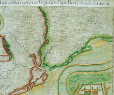
| Figure 1 Detail of Edward Crisp, A Compleat Description of the Province of carolina in 3 Parts. 1st The Improved part from the Survey’s of Maurice Mathews & Mr. John Love. 2ly. the West part by Capt. Thos. Narin. 3ly A Chart of the Coast from Virginia to Cape Florieda. Colored engraving. 32 3/4" x 40". (Courtesy, South Caroliniana Library, University of South Carolina, Columbia, South Carolina; photo, Museum of Early Southern Decorative Arts.) This map was engraved by John Harris in London and published by Crisp about 1711. |